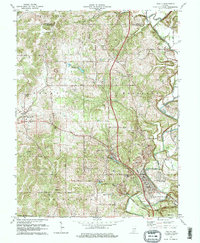
1978 Map of Oolitic
USGS Topo · Published 1978About this map
Oolitic and its surrounding limestone country are defined by a complex industrial and transport network in this late 1970s survey. The landscape is marked by numerous quarry operations and infrastructure such as the Pumping Station and Water Tank, reflecting the region's deep ties to stone production. Along Salt Creek, the rail lines of the Louisville and Nashville and the Chicago Milwaukee St Paul and Pacific provide the primary corridors for commerce, connecting smaller settlements like Guthrie, Peerless, and Murdock. Significant local landmarks include the Purdue University Experimental Farm and several community hubs such as Valley Mission Ch and Mt Zion Ch. This map records the rural development pattern of Lawrence Co before further modernization, preserving the locations of family-named sites like Anderson Cem and topographic features like Dark Hollow and Patton Hill.
Find a feature on this map
46 named features on this map. Tap any name to fly to it.
Don’t see what you’re looking for? This feature index may not catch every label — zoom into the map to look around manually.
Map Details
Editions of this 1978 Oolitic Map
3 editions found
Other maps of this area

1908 · Bloomington
USGS Topo · 1:48,000

1910 · Bloomington
USGS Topo · 1:62,500

1934 · Bedford
USGS Topo · 1:48,000

1935 · Oolitic
USGS Topo · 1:48,000

1937 · Bedford
USGS Topo · 1:62,500

1942 · Franklin
USGS Topo · 1:125,000

1942 · Oolitic
USGS Topo · 1:62,500

1947 · Allens Creek
USGS Topo · 1:24,000

1953 · Indianapolis
USGS Topo · 1:250,000

1956 · Indianapolis
USGS Topo · 1:250,000