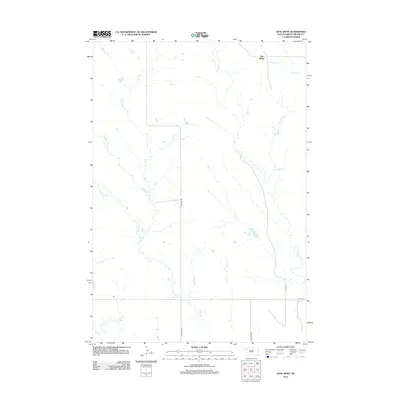
2012 Map of Opal West
USGS Topo · Published 2012About this map
Fox Ridge stands as a prominent topographic anchor in this portion of Meade County, where the high ground transitions into a complex system of drainage basins. The landscape is defined by the intricate dendritic patterns of the Pine Cr network, including its various forks such as the Middle Br Pine Cr, W Br Pine Cr, and E Br Pine Cr. These watercourses shape the ranching and agricultural territory of western South Dakota, drawing toward seasonal collection points like Vansickel Lake. A sparse but essential road network, including Maurine Rd and Opal Rd, follows the section lines, reflecting the organized land division of the Great Plains. This survey captures the rural character of the region, where life and transit are dictated by the natural draws and the long stretches of gravel roads connecting isolated homesteads to the wider county.
Find a feature on this map
13 named features on this map. Tap any name to fly to it.
Don’t see what you’re looking for? This feature index may not catch every label — zoom into the map to look around manually.
Map Details
Editions of this 2012 Opal West Map
This is the sole edition of this map. No revisions or reprints were ever made.
Other maps of this area

1951 · Cedar Canyon
USGS Topo · 1:24,000

1951 · Maurine
USGS Topo · 1:24,000

1952 · Signal Butte
USGS Topo · 1:24,000

1953 · Rapid City
USGS Topo · 1:250,000

1954 · Lemmon
USGS Topo · 1:250,000

1957 · Lemmon
USGS Topo · 1:250,000

1957 · Rapid City
USGS Topo · 1:250,000

1983 · Opal West SE
USGS Topo · 1:24,000
1983 · Squaw Buttes
USGS Topo · 1:24,000
1983 · Opal East
USGS Topo · 1:24,000