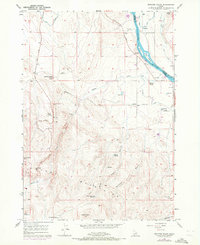
1957 Map of Opalene Gulch
USGS Topo · Published 1972About this map
The Snake River flows through the high desert of southwest Idaho, carving a path between Owyhee and Canyon counties. This 1957 survey, with updates from 1971, reveals a landscape defined by complex irrigation efforts and rugged terrain. Water from the river is diverted into a network of channels including the Owyhee Canal, the Conroy Lateral, and the Deer Flat Low Line Canal, supporting small pockets of activity like Riverside and the Opalene School.
Find a feature on this map
34 named features on this map. Tap any name to fly to it.
Don’t see what you’re looking for? This feature index may not catch every label — zoom into the map to look around manually.
Map Details
Editions of this 1957 Opalene Gulch Map
2 editions found
Other maps of this area

1892 · Silver City
USGS Topo · 1:125,000

1894 · Silver City
USGS Topo · 1:125,000

1898 · Nampa
USGS Topo · 1:125,000

1898 · Silver City
USGS Topo · 1:125,000

1955 · Boise
USGS Topo · 1:250,000

1957 · Opalene Gulch
USGS Topo · 1:24,000

1957 · Wilson Peak
USGS Topo · 1:24,000

1957 · Sands Basin
USGS Topo · 1:62,500

1958 · Boise
USGS Topo · 1:250,000
1958 · Givens Hot Springs
USGS Topo · 1:24,000