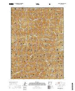
2020 Map of Ophir Mountain
USGS Topo · Published 2020About this map
Ophir Mtn and the surrounding high ridges of the Siskiyou National Forest dominate this section of the Oregon Coast Range along the Coos and Curry county line. This environment is defined by its complex drainage systems, where the protected Elk Wild and Scenic River carves through the center of the sheet, joined by tributaries like Slide Cr and Milbury Cr. The map details a landscape of extreme relief, from the peak of Copper Mtn to the curiously named Devils Half Acre and Bonanza Basin. While the area is largely devoid of traditional settlements, the network of timber-access roads, such as the one traversing Iron Mtn, highlights the region's historical and ongoing connection to the Pacific Northwest forest industry. High-elevation water bodies like Laird Lake and Mud Lake provide essential landmarks for navigation within this dense terrain.
Find a feature on this map
33 named features on this map. Tap any name to fly to it.
Don’t see what you’re looking for? This feature index may not catch every label — zoom into the map to look around manually.
Map Details
Editions of this 2020 Ophir Mountain Map
This is the sole edition of this map. No revisions or reprints were ever made.
Other maps of this area

1899 · Port Orford
USGS Topo · 1:125,000

1903 · Port Orford
USGS Topo · 1:125,000

1954 · Coos Bay
USGS Topo · 1:250,000

1954 · Port Orford
USGS Topo · 1:62,500

1954 · Agness
USGS Topo · 1:62,500

1954 · Powers
USGS Topo · 1:62,500

1954 · Langlois
USGS Topo · 1:62,500

1958 · Coos Bay
USGS Topo · 1:250,000

1962 · Coos Bay
USGS Topo · 1:250,000
1986 · Father Mountain
USGS Topo · 1:24,000