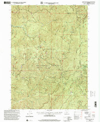
1998 Map of Ophir Mountain
USGS Topo · Published 2001About this map
The Siskiyou National Forest dominates this terrain where the peaks of Ophir Mountain and Iron Mountain define the drainage basins of the Elk River and Lobster Creek. This 1990s landscape reveals a history of backcountry activity, from the remote Toast Camp and McCurdy Camp to the industrial mark of the Bonanza Basin Mine and several quarries. Recreation and management are evident at the Laird Lake Campground and various communication towers perched on high ridges. The map also traces the winding boundary between Coos County and Curry County, following the complex topographical divides of Copper Mountain and Panther Mountain as they rise above the winding paths of Poverty Creek and Blackberry Creek.
Find a feature on this map
33 named features on this map. Tap any name to fly to it.
Don’t see what you’re looking for? This feature index may not catch every label — zoom into the map to look around manually.
Map Details
Editions of this 1998 Ophir Mountain Map
This is the sole edition of this map. No revisions or reprints were ever made.
Other maps of this area

1899 · Port Orford
USGS Topo · 1:125,000

1903 · Port Orford
USGS Topo · 1:125,000

1954 · Coos Bay
USGS Topo · 1:250,000

1954 · Port Orford
USGS Topo · 1:62,500

1954 · Agness
USGS Topo · 1:62,500

1954 · Powers
USGS Topo · 1:62,500

1954 · Langlois
USGS Topo · 1:62,500

1958 · Coos Bay
USGS Topo · 1:250,000

1962 · Coos Bay
USGS Topo · 1:250,000
1986 · Father Mountain
USGS Topo · 1:24,000