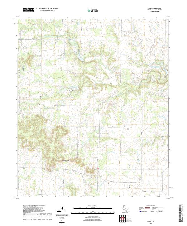
2022 Map of Oplin
USGS Topo · Published 2022About this map
The small rural community of Oplin serves as the focal point for this section of Callahan County, where Farm to Market roads intersect against a landscape defined by ranching and water management. Significant genealogical landmarks include the Tecumseh Cem and Oplin Cem, which preserve the history of the early families who settled this high ground. The terrain is marked by the prominent Tecumseh Peak, rising above the drainage basins of South Prong Pecan Bayou and Clear Cr. Modern land use is evident through various water-retention projects like the Soil Conservation Service Site 32 Reservoir and the Soil Conservation Service Site 110 Reservoir, designed to manage runoff in this part of the Texas plains. Numerous named branches, such as Lick Br and Camp Br, feed into the larger bayou system, illustrating the vital role of seasonal waterways in this environment.
Find a feature on this map
40 named features on this map. Tap any name to fly to it.
Don’t see what you’re looking for? This feature index may not catch every label — zoom into the map to look around manually.
Map Details
Editions of this 2022 Oplin Map
This is the sole edition of this map. No revisions or reprints were ever made.
Other maps of this area

1890 · Abilene
USGS Topo · 1:125,000

1892 · Abilene
USGS Topo · 1:125,000

1931 · Baird
USGS Topo · 1:125,000

1932 · Baird
USGS Topo · 1:125,000

1954 · Abilene
USGS Topo · 1:250,000

1957 · Kirby Lake
USGS Topo · 1:62,500

1958 · Abilene
USGS Topo · 1:250,000
1960 · Crooked Creek
USGS Topo · 1:24,000
1966 · Cub Hollow
USGS Topo · 1:24,000
1967 · McEwen Draw
USGS Topo · 1:24,000