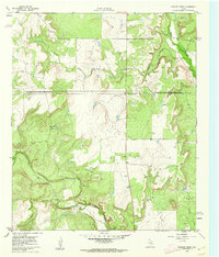
1960 Map of Crooked Creek
USGS Topo · Published 1962About this map
Jim Ned Creek and Crooked Creek carve through this landscape at the transition between Callahan and Coleman counties during the early 1960s. The area is defined by its industrial activity, with numerous Quarry sites and Oil Wells scattered across the terrain, indicating a mid-century reliance on resource extraction. Small-scale development is localized near geographic markers like Ranger and a network of watercourses including Herd Branch and Pecan Creek. A distinctive historical detail is the notation of conflicting surveys, specifically the Coleman County Boundary Survey of 1885 and the Callahan County Boundary Survey of 1898, which highlight the complexities of land division in rural Texas. The map also features several survey markers such as BM 1959 Oplin and BM 1786, providing precise data points for genealogists and surveyors tracing property lines and land use.
Find a feature on this map
16 named features on this map. Tap any name to fly to it.
Don’t see what you’re looking for? This feature index may not catch every label — zoom into the map to look around manually.
Map Details
Editions of this 1960 Crooked Creek Map
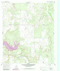
2 editions found
Other maps of this area

1887 · Coleman
USGS Topo · 1:125,000

1889 · Coleman
USGS Topo · 1:125,000

1890 · Abilene
USGS Topo · 1:125,000

1892 · Abilene
USGS Topo · 1:125,000

1892 · Ballinger
USGS Topo · 1:125,000

1931 · Baird
USGS Topo · 1:125,000

1932 · Baird
USGS Topo · 1:125,000

1954 · Brownwood
USGS Topo · 1:250,000

1954 · Abilene
USGS Topo · 1:250,000

1958 · Abilene
USGS Topo · 1:250,000