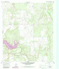
1960 Map of Crooked Creek
USGS Topo · Published 1987About this map
Lake Coleman dominates the southwestern portion of this landscape, its waters reaching into the surrounding drainages of Jim Ned Creek and Salt Branch. The terrain is defined by the winding course of Crooked Creek, which cuts across the central and northern sections of the map, fed by smaller tributaries like Herd Branch. The land use here is characterized by resource extraction, with numerous labels for Oil Wells and multiple Quarries scattered throughout the hills. This 1960 field-checked survey, updated with 1984 aerial data, captures the intersection of Coleman Co and Callahan Co, showing a rural Texas landscape where the expanding reservoir and established oil infrastructure coexist alongside the established water system of Pecan Bayou.
Find a feature on this map
17 named features on this map. Tap any name to fly to it.
Don’t see what you’re looking for? This feature index may not catch every label — zoom into the map to look around manually.
Map Details
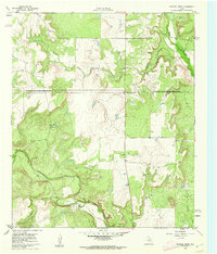
Editions of this 1960 Crooked Creek Map
2 editions found
Other maps of this area

1887 · Coleman
USGS Topo · 1:125,000

1889 · Coleman
USGS Topo · 1:125,000

1890 · Abilene
USGS Topo · 1:125,000

1892 · Abilene
USGS Topo · 1:125,000

1892 · Ballinger
USGS Topo · 1:125,000

1931 · Baird
USGS Topo · 1:125,000

1932 · Baird
USGS Topo · 1:125,000

1954 · Brownwood
USGS Topo · 1:250,000

1954 · Abilene
USGS Topo · 1:250,000

1958 · Abilene
USGS Topo · 1:250,000