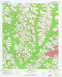
1971 Map of Opp West
USGS Topo · Published 1973About this map
The western edge of Opp serves as the hub of this 1970s survey, where the Louisville and Nashville railroad tracks parallel the Yellow River. This landscape reflects the educational and community infrastructure of Covington County, featuring the Douglas MacArthur State Tech Inst and the South Highland Sch. To the west, the terrain transitions into a pattern of rural settlements and family-named landmarks like Wiggins and Harmony.
Find a feature on this map
59 named features on this map. Tap any name to fly to it.
Don’t see what you’re looking for? This feature index may not catch every label — zoom into the map to look around manually.
Map Details
Editions of this 1971 Opp West Map
2 editions found
Other maps of this area

1953 · Andalusia
USGS Topo · 1:250,000

1957 · Andalusia
USGS Topo · 1:250,000

1968 · Danleys Crossroads
USGS Topo · 1:24,000

1968 · Opp East
USGS Topo · 1:24,000
1969 · Kinston
USGS Topo · 1:24,000

1971 · Libertyville
USGS Topo · 1:24,000

1971 · Dozier
USGS Topo · 1:24,000

1971 · Onycha
USGS Topo · 1:24,000

1971 · Andalusia
USGS Topo · 1:24,000

1971 · Gantt
USGS Topo · 1:24,000