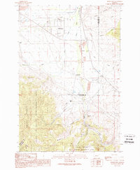
1989 Map of Opportunity
USGS Topo · Published 1989About this map
Opportunity and the neighboring settlements of Stuart and Crackerville occupy a landscape defined by industrial water management and regional transit corridors along the boundary of Deer Lodge and Silver Bow counties. The map highlights a complex hydrography where Mill Creek and Willow Creek meet the Mill-Willow Bypass, channeling water toward the headwaters of Silver Bow Creek. This late-twentieth-century survey reveals the industrial footprint of the region, marked by numerous Gravel Pits and remnants of an old RR Grade, contrasted against the preserved terrain of the Mount Haggin State Wildlife Management Area and the Deerlodge National Forest. Further south, the map identifies small rail-related sites such as Finlen, Durant, and the Hackney (Site) near German Gulch, illustrating the legacy of the area's mining and transportation history.
Find a feature on this map
32 named features on this map. Tap any name to fly to it.
Don’t see what you’re looking for? This feature index may not catch every label — zoom into the map to look around manually.
Map Details
Editions of this 1989 Opportunity Map
This is the sole edition of this map. No revisions or reprints were ever made.
Other maps of this area

1889 · Helena
USGS Topo · 1:250,000

1893 · Helena
USGS Topo · 1:250,000

1893 · Dillon
USGS Topo · 1:250,000

1899 · Helena
USGS Topo · 1:250,000

1903 · Helena
USGS Topo · 1:250,000

1947 · Butte
USGS Topo · 1:250,000

1955 · Dillon
USGS Topo · 1:250,000

1957 · Dillon
USGS Topo · 1:250,000

1958 · Butte
USGS Topo · 1:250,000

1958 · Dillon
USGS Topo · 1:250,000