
1967 Map of Optima
USGS Topo · Published 1968About this map
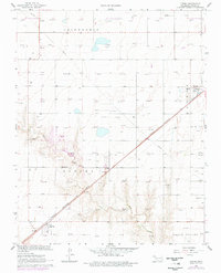
Chicago Rock Island and Pacific railroad tracks cut a sharp diagonal across the High Plains of the Oklahoma Panhandle, anchoring the small settlements of Optima and Panoma. This 1960s landscape is defined by the heavy footprint of the energy industry, with a dense network of Gas Wells, an Oil Well, and a Refinery near Midway illustrating the region's mid-century economic drivers. The terrain, including the broad reaches of Friendship and Grand Valley, is dotted with specialized infrastructure like Radio Towers and a Landing Field, while the hydrology is dominated by the seasonal course of Pony Creek. Local resource extraction is further evidenced by several Caliche Pits and Gravel Pits scattered throughout the territory, marking a period when infrastructure and industrial development were actively reshaping the plains of Texas County.
Find a feature on this map
22 named features on this map. Tap any name to fly to it.
Don’t see what you’re looking for? This feature index may not catch every label — zoom into the map to look around manually.
Map Details
Editions of this 1967 Optima Map
2 editions found
Other maps of this area

1954 · Perryton
USGS Topo · 1:250,000

1958 · Perryton
USGS Topo · 1:250,000

1967 · Straight
USGS Topo · 1:24,000

1967 · Straight NE
USGS Topo · 1:24,000

1967 · Straight SW
USGS Topo · 1:24,000

1967 · Hooker
USGS Topo · 1:24,000

1967 · Hooker NW
USGS Topo · 1:24,000

1968 · Optima Dam
USGS Topo · 1:24,000

1968 · Guymon
USGS Topo · 1:24,000

1968 · Guymon NE
USGS Topo · 1:24,000