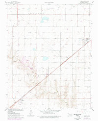
1967 Map of Optima
USGS Topo · Published 1977About this map
Chicago Rock Island and Pacific tracks dominate the landscape of the Oklahoma Panhandle in this late 1960s survey, cutting diagonally across the high plains. The settlement of Optima sits at the base of the map, marked by a Water Tank and a dense collection of structures, while the smaller community of Panoma serves as a northern waypoint for the railroad. The region’s economic lifeblood is evident in the dense distribution of gas and oil wells, supported by industrial features like a Refinery near Midway and various Caliche Pits used for local road materials. The transition from the flat tablelands of Friendship to the eroded breaks of Pony Creek illustrates the subtle but complex drainage patterns that shape this cattle and energy-producing country.
Find a feature on this map
16 named features on this map. Tap any name to fly to it.
Don’t see what you’re looking for? This feature index may not catch every label — zoom into the map to look around manually.
Map Details
Editions of this 1967 Optima Map
2 editions found
Other maps of this area

1954 · Perryton
USGS Topo · 1:250,000

1958 · Perryton
USGS Topo · 1:250,000

1967 · Straight
USGS Topo · 1:24,000

1967 · Straight NE
USGS Topo · 1:24,000

1967 · Straight SW
USGS Topo · 1:24,000

1967 · Optima
USGS Topo · 1:24,000

1967 · Hooker
USGS Topo · 1:24,000

1967 · Hooker NW
USGS Topo · 1:24,000

1968 · Optima Dam
USGS Topo · 1:24,000

1968 · Guymon
USGS Topo · 1:24,000