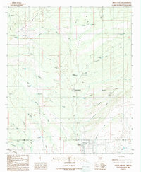
1988 Map of Oracle Junction
USGS Topo · Published 1989About this map
Oracle Junction sits at the nexus of a desert landscape defined by high-elevation drainage systems and the transition between Pinal and Pima counties in the late 1980s. This survey illustrates the intricate network of washes and gulches that channel water through Falcon Valley, including Suizo Wash and Big Wash, which serve as vital topographic markers in this arid environment. The map captures the infrastructure of the era, from a dedicated Roadside Park near the junction to the scattered ranching and utility features like the Small Hill Reservoir and numerous holding tanks.
Find a feature on this map
57 named features on this map. Tap any name to fly to it.
Don’t see what you’re looking for? This feature index may not catch every label — zoom into the map to look around manually.
Map Details
Editions of this 1988 Oracle Junction Map
2 editions found
Other maps of this area

1904 · Tucson
USGS Topo · 1:125,000

1905 · Tucson
USGS Topo · 1:125,000

1911 · Winkelman
USGS Topo · 1:125,000

1913 · Winkelman
USGS Topo · 1:125,000

1934 · Tucson Mountains
USGS Topo · 1:125,000

1934 · Newman Peak
USGS Topo · 1:125,000

1947 · Cortaro
USGS Topo · 1:62,500

1956 · Tucson
USGS Topo · 1:250,000

1957 · Cortaro
USGS Topo · 1:62,500
1957 · Mount Lemmon
USGS Topo · 1:62,500