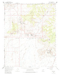
1966 Map of Oraibi
USGS Topo · Published 1983About this map
The Hopi Indian Reservation landscape is defined by the high, flat-topped formations of Third Mesa and Second Mesa, where ancient villages and sacred sites cluster along the rocky rims. This 1966 survey documents the cultural geography of the region, showing established settlements like Old Oraibi and Hotevilla alongside historic sites such as Ma Shon Pi and Huck Ovi. The map captures a rare level of detail regarding traditional land use and history, including the Tug-of-War Historical Marker and numerous named springs like Bluebird Spring and Brownrock Spring that sustain life in the arid environment. Water management is evident through various water tanks and a sewage disposal pond, while the surrounding terrain is marked by the winding paths of Oraibi Wash and Dinnebito Wash, framing a resilient community at the heart of the high desert.
Find a feature on this map
53 named features on this map. Tap any name to fly to it.
Don’t see what you’re looking for? This feature index may not catch every label — zoom into the map to look around manually.
Map Details
Editions of this 1966 Oraibi Map
2 editions found

Other maps of this area

1883 · Marsh Pass
USGS Topo · 1:250,000

1883 · Tusayan
USGS Topo · 1:250,000

1886 · Tusayan
USGS Topo · 1:250,000

1892 · Marsh Pass
USGS Topo · 1:250,000

1947 · Flagstaff
USGS Topo · 1:250,000

1954 · Flagstaff
USGS Topo · 1:250,000

1956 · Marble Canyon
USGS Topo · 1:250,000

1958 · Flagstaff
USGS Topo · 1:250,000

1959 · Marble Canyon
USGS Topo · 1:250,000

1960 · Flagstaff
USGS Topo · 1:250,000