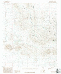
1987 Map of Orange Butte
USGS Topo · Published 1987About this map
Orange Butte stands as a prominent landmark in this desert landscape where Cochise, Graham, and Greenlee counties meet. This 1980s provisional survey illustrates a region defined by its vital water sources, where isolated improvements like Old Camp Windmill and Horsecamp Windmill supported ranching operations. The terrain is deeply incised by drainages such as Whitehorse Canyon and Lighting Canyon, which converge toward the Tule Wells area. The presence of named water features like Indian Tanks, Tule Tank, and Sands Well suggests the critical importance of reliable water in this arid environment. Surveyed during the late 20th century, the map documents the network of unimproved roads and trails that connected these remote outposts, including Robs Well and Midway Peak, providing a clear view of the land use patterns and topographical challenges of the high desert before modern developments.
Find a feature on this map
24 named features on this map. Tap any name to fly to it.
Don’t see what you’re looking for? This feature index may not catch every label — zoom into the map to look around manually.
Map Details
Editions of this 1987 Orange Butte Map
This is the sole edition of this map. No revisions or reprints were ever made.
Other maps of this area

1917 · San Simon
USGS Topo · 1:125,000

1926 · Orange Butte
USGS Topo · 1:62,500

1928 · Bowie
USGS Topo · 1:62,500

1949 · Bowie
USGS Topo · 1:62,500

1950 · San Simon
USGS Topo · 1:62,500

1950 · Bowie
USGS Topo · 1:62,500

1951 · San Simon
USGS Topo · 1:62,500

1954 · Silver City
USGS Topo · 1:250,000

1958 · Silver City
USGS Topo · 1:250,000

1960 · Duncan
USGS Topo · 1:62,500