
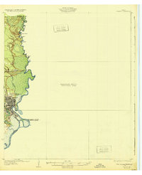
1932 Map of Orange
USGS Topo · Published 1932About this map
The Orange street grid and the industrial activity of the Sabine River corridor dominate this 1932 preliminary survey of southeastern Texas. The map illustrates a landscape defined by its waterways, where the river serves as both a primary transport artery and a complex political boundary between Texas and Louisiana. To the north, the small settlement of Echo sits near the crossing of the Southern Pacific railroad, highlighting the era's reliance on rail-to-water transshipment. The western bank is marked by a series of prominent elevations including Morgan Bluff, Pruett Bluff, and West Bluff, which provide topographical relief against the low-lying marshlands and bayous. Inland, the map traces the winding courses of Adams Bayou and Cypress Bayou, while river features like Morgan Eddy and Grubs I reflect the shifting nature of the waterway. This edition is unique for its large block of unsurveyed territory to the east, focusing strictly on the developed and geographically critical riverfront during the early 1930s.
Find a feature on this map
16 named features on this map. Tap any name to fly to it.
Don’t see what you’re looking for? This feature index may not catch every label — zoom into the map to look around manually.
Map Details
Editions of this 1932 Orange Map
2 editions found
Other maps of this area

1926 · Mauriceville
USGS Topo · 1:24,000

1932 · Port Arthur NE
USGS Topo · 1:31,680

1934 · Greens Bayou
USGS Topo · 1:24,000

1934 · Browns Lake
USGS Topo · 1:24,000

1934 · Five Lakes
USGS Topo · 1:24,000

1935 · Five Lakes
USGS Topo · 1:31,680

1935 · Browns Lake
USGS Topo · 1:31,680

1935 · Greens Bayou
USGS Topo · 1:31,680

1943 · West of Greens Bayou
USGS Topo · 1:24,000

1943 · Orangefield
USGS Topo · 1:24,000