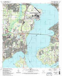
1993 Map of Orange Park
USGS Topo · Published 1993About this map
The St Johns River and Doctors Lake define the suburban and military landscape of this region south of Jacksonville during the early 1990s. The massive footprint of the Jacksonville Naval Air Station dominates the peninsula between the river and the Ortega River, featuring extensive airfield infrastructure and housing at Yukon. The residential expansion of Orange Park and Bellair is evident, while across the Buckman Bridge, the historic community of Mandarin maintains a distinct character with its numerous small churches like First Christian Ch and Ch of Our Savior. Genealogical interest is found in the Magnolia Cem and Jacksonville Memory Gardens, which sit alongside established neighborhoods. The Seaboard System railroad tracks cut through the western settlements, serving as a reminder of the corridor's long-standing role as a primary transportation artery into the Florida peninsula.
Find a feature on this map
75 named features on this map. Tap any name to fly to it.
Don’t see what you’re looking for? This feature index may not catch every label — zoom into the map to look around manually.
Map Details
Editions of this 1993 Orange Park Map
2 editions found
Other maps of this area

1917 · Orange Park
USGS Topo · 1:62,500

1917 · Cambon
USGS Topo · 1:62,500

1918 · Middleburg
USGS Topo · 1:62,500

1918 · Cambon
USGS Topo · 1:62,500

1918 · Jacksonville
USGS Topo · 1:62,500

1918 · Orange Park
USGS Topo · 1:62,500

1941 · Middleburg
USGS Topo · 1:62,500

1948 · Jacksonville
USGS Topo · 1:250,000

1949 · Middleburg
USGS Topo · 1:24,000

1949 · Jacksonville Heights
USGS Topo · 1:24,000