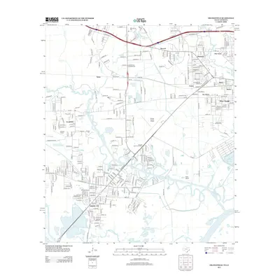
2012 Map of Orangefield
USGS Topo · Published 2012About this map
Cow Bayou and its winding tributaries dominate this 2012 survey of the Texas-Louisiana borderlands, defining the landscape between Bridge City and West Orange. The area's aviation and transport infrastructure is well-documented, featuring both the Orange County Airport and Chesson Airport, alongside the major corridor of Old Highway 90. The residential patterns are punctuated by numerous local cemeteries, such as Dorman Cem, Winfree Cem, and Granger Cem, which offer significant value for genealogists tracing family histories in the smaller settlements of Orangefield, Bancroft, and Tulane. Near the southeastern corner, the industrial and natural geography merge where the Shell Canal meets the Sabine River, and the Plant Reservoir sits adjacent to the intricate wetlands surrounding Mule Island.
Find a feature on this map
38 named features on this map. Tap any name to fly to it.
Don’t see what you’re looking for? This feature index may not catch every label — zoom into the map to look around manually.
Map Details
Editions of this 2012 Orangefield Map
This is the sole edition of this map. No revisions or reprints were ever made.
Other maps of this area

1926 · Terry
USGS Topo · 1:24,000

1926 · Texla
USGS Topo · 1:24,000

1926 · Mauriceville
USGS Topo · 1:24,000

1932 · Orange
USGS Topo · 1:62,500

1932 · Port Arthur NE
USGS Topo · 1:31,680

1934 · Greens Bayou
USGS Topo · 1:24,000

1935 · Greens Bayou
USGS Topo · 1:31,680

1943 · West of Greens Bayou
USGS Topo · 1:24,000

1943 · Orangefield
USGS Topo · 1:24,000

1943 · Mauriceville
USGS Topo · 1:24,000