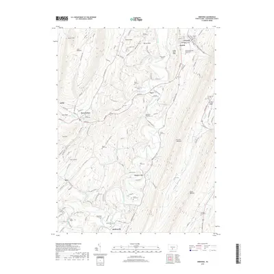
2019 Map of Orbisonia
USGS Topo · Published 2019About this map
Aughwick Creek carves a central path through this section of the Ridge-and-Valley Appalachians, defining the local geography between Jacks Mountain and Shade Mountain. This 2019 survey reflects a rural landscape where family heritage remains deeply etched into the terrain, evidenced by numerous private burial grounds such as the Flasher Family Cem and Baker Family Cem. The twin boroughs of Orbisonia and Rockhill serve as the primary cultural anchors in the northeast, maintaining their historical footprint alongside the East Broad Top RR. Transport routes like the Maddensville Pike connect smaller settlements including Meadow Gap and Maddensville, following the natural contours of Monroe Valley and Locke Valley. The presence of the Saint Mary's Covered Bridge near the eastern edge of the map highlights the preservation of traditional infrastructure within this Huntingdon County corridor.
Find a feature on this map
135 named features on this map. Tap any name to fly to it.
Don’t see what you’re looking for? This feature index may not catch every label — zoom into the map to look around manually.
Map Details
Editions of this 2019 Orbisonia Map
This is the sole edition of this map. No revisions or reprints were ever made.
Other maps of this area

1901 · Huntingdon
USGS Topo · 1:62,500

1904 · Huntingdon
USGS Topo · 1:62,500

1922 · Mt Union
USGS Topo · 1:48,000

1924 · Mt. Union
USGS Topo · 1:62,500

1930 · Broad Top
USGS Topo · 1:62,500

1933 · Broad Top
USGS Topo · 1:62,500

1939 · Orbisonia
USGS Topo · 1:62,500

1940 · Orbisonia
USGS Topo · 1:62,500

1944 · Orbisonia
USGS Topo · 1:62,500

1944 · Mt. Union
USGS Topo · 1:62,500