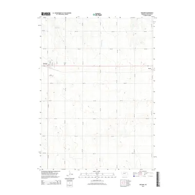
2014 Map of Orchard
USGS Topo · Published 2014About this map
The village of Orchard serves as the primary hub of this northern Nebraska landscape, situated along a grid of section-line roads that define the region's agricultural character. The town site includes street-level detail such as Noble St, E 3rd St, and Rusk St, with the Orchard Cem located just to the east. The terrain is marked by essential water management features, including the Schleusener Reservoir and the drainage of Hathaway Slough. Further east, the small settlement of Royal sits near the edge of the quadrangle. For genealogists and local historians, the presence of both the town cemetery and Saint Peters Cem provides specific points of interest for tracing family roots within this rural community. The map's detail of local creeks, such as Hay Cr, and the extensive rural road network illustrates the 21st-century connectivity of this part of Antelope County.
Find a feature on this map
18 named features on this map. Tap any name to fly to it.
Don’t see what you’re looking for? This feature index may not catch every label — zoom into the map to look around manually.
Map Details
Editions of this 2014 Orchard Map
This is the sole edition of this map. No revisions or reprints were ever made.
Other maps of this area

1955 · O'Neill
USGS Topo · 1:250,000

1959 · O'Neill
USGS Topo · 1:250,000

1963 · Orchard NE
USGS Topo · 1:24,000

1963 · Neligh
USGS Topo · 1:24,000

1963 · Venus
USGS Topo · 1:24,000

1963 · Royal
USGS Topo · 1:24,000

1963 · Orchard
USGS Topo · 1:24,000

1963 · Ewing
USGS Topo · 1:24,000

1963 · Deloit NE
USGS Topo · 1:24,000
1963 · Clearwater
USGS Topo · 1:24,000