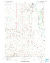
1966 Map of Orchard Bench
USGS Topo · Published 1969About this map
The Bighorn River corridor near Basin exhibits a complex system of irrigation and transit infrastructure in the mid-1960s. The Big Horn Canal and various siphons and pipelines navigate the terrain of Orchard Bench, supporting the agricultural character of this Wyoming river valley. Cultural landmarks outside the town center include the State Sanatarium, a Drive-in Theater, and the local Fairground, illustrating the community hubs of the era.
Find a feature on this map
25 named features on this map. Tap any name to fly to it.
Don’t see what you’re looking for? This feature index may not catch every label — zoom into the map to look around manually.
Map Details
Editions of this 1966 Orchard Bench Map
2 editions found
Other maps of this area

1951 · Schuster Flats NE
USGS Topo · 1:24,000

1951 · Schuster Flats NW
USGS Topo · 1:24,000

1955 · Cody
USGS Topo · 1:250,000

1955 · Sheridan
USGS Topo · 1:250,000

1958 · Cody
USGS Topo · 1:250,000

1958 · Sheridan
USGS Topo · 1:250,000

1960 · Manderson
USGS Topo · 1:24,000

1960 · Wild Horse Flats
USGS Topo · 1:24,000

1962 · Sheridan
USGS Topo · 1:250,000

1962 · Cody
USGS Topo · 1:250,000