
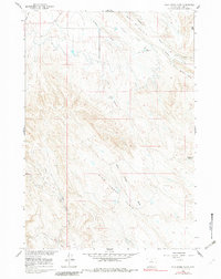
1960 Map of Wild Horse Flats
USGS Topo · Published 1962About this map
Industrial development in the Big Horn Basin is clearly evident across Wild Horse Flats in this 1960 field check. The landscape is defined by the energy sector, specifically the established petroleum operations at Torchlight Field and Lamb Field. Numerous Oil Wells and a dedicated Radio Tower point to the technical infrastructure required for resource extraction in this arid Wyoming environment.
Find a feature on this map
22 named features on this map. Tap any name to fly to it.
Don’t see what you’re looking for? This feature index may not catch every label — zoom into the map to look around manually.
Map Details
Editions of this 1960 Wild Horse Flats Map
2 editions found
Other maps of this area

1898 · Bald Mountain
USGS Topo · 1:125,000

1901 · Bald Mountain
USGS Topo · 1:125,000

1955 · Cody
USGS Topo · 1:250,000

1955 · Sheridan
USGS Topo · 1:250,000

1958 · Cody
USGS Topo · 1:250,000

1958 · Sheridan
USGS Topo · 1:250,000

1960 · Manderson
USGS Topo · 1:24,000

1960 · Manderson NE
USGS Topo · 1:24,000

1960 · Devils Kitchen
USGS Topo · 1:24,000

1960 · Shell
USGS Topo · 1:24,000