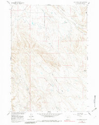
1960 Map of Wild Horse Flats
USGS Topo · Published 1982About this map
The Lamb Oil Field and Torchlight Oil Field dominate the southwest portion of this landscape, marking a period of significant energy development in Big Horn County during the late 1950s. The terrain transitions from the high ground of Potato Ridge and Fox Mtn in the northeast down toward the expansive Wild Horse Flats. Water management for this arid region is visible through the engineering of the Shell Canal and several catchment points, including Thomas Coulee Reservoir, Carey Reservoir, and Jones Reservoir. A network of unpaved travel ways, including a named Jeep Trail, connects these remote industrial and agricultural sites across a series of draws and gulches like Dead Horse Gulch and Frenchy Draw. The map reflects a working landscape where early 20th-century irrigation efforts met the post-war oil boom.
Find a feature on this map
25 named features on this map. Tap any name to fly to it.
Don’t see what you’re looking for? This feature index may not catch every label — zoom into the map to look around manually.
Map Details
Editions of this 1960 Wild Horse Flats Map
2 editions found

Other maps of this area

1898 · Bald Mountain
USGS Topo · 1:125,000

1901 · Bald Mountain
USGS Topo · 1:125,000

1955 · Cody
USGS Topo · 1:250,000

1955 · Sheridan
USGS Topo · 1:250,000

1958 · Cody
USGS Topo · 1:250,000

1958 · Sheridan
USGS Topo · 1:250,000

1960 · Manderson
USGS Topo · 1:24,000

1960 · Manderson NE
USGS Topo · 1:24,000

1960 · Devils Kitchen
USGS Topo · 1:24,000

1960 · Shell
USGS Topo · 1:24,000