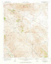
1961 Map of Orchard Peak
USGS Topo · Published 1962About this map
The Temblor Range and San Luis Obispo and Kern County line dominate this early 1960s survey of the California Coast Ranges. The map documents an arid, industrializing landscape where water management and oil extraction shape the human footprint. Significant infrastructure, including the Antelope Pumping Sta and a long-distance Pipeline, underscores the region's role in the state's resource network. Small settlements like Annette and Kecks Corner appear alongside more remote mountain crossings such as Palo Prieto Pass and Polonio Pass. The geography is characterized by several distinct basins, notably Barrel Valley and Choice Valley, separated by dramatic ridges like Bluestone Ridge. Ephemeral water features like Twisselmann Lake and Long Lake suggest a seasonal hydrological cycle, while the presence of Oil Wells near Devils Den marks the northern extent of the local petroleum fields.
Find a feature on this map
54 named features on this map. Tap any name to fly to it.
Don’t see what you’re looking for? This feature index may not catch every label — zoom into the map to look around manually.
Map Details
Editions of this 1961 Orchard Peak Map
This is the sole edition of this map. No revisions or reprints were ever made.
Other maps of this area

1912 · McKittrick
USGS Topo · 1:125,000

1914 · Lost Hills
USGS Topo · 1:125,000

1914 · Cholame
USGS Topo · 1:125,000

1915 · Cholame
USGS Topo · 1:125,000

1917 · Cholame
USGS Topo · 1:125,000

1922 · Pozo
USGS Topo · 1:62,500

1930 · Avenal Gap
USGS Topo · 1:31,680

1932 · La Panza
USGS Topo · 1:48,000
1933 · Avenal Gap
USGS Topo · 1:31,680

1935 · La Panza
USGS Topo · 1:62,500