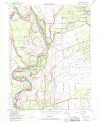
1949 Map of Ord Ferry
USGS Topo · Published 1971About this map
The Sacramento River carves a complex, shifting path through the valley at the junction of Butte and Glenn Counties, creating a landscape defined by seasonal sloughs and islands. Large land grants like Jacinto, Capay, and Llano Seco anchor the terrain, reflecting the area's agricultural heritage. The river's historical importance as a transit corridor is marked by the Ord Ferry (Site) near Ryan, while the Southern Pacific railroad runs through the northeast corner past Bidwell Sch.
Find a feature on this map
50 named features on this map. Tap any name to fly to it.
Don’t see what you’re looking for? This feature index may not catch every label — zoom into the map to look around manually.
Map Details
Editions of this 1949 Ord Ferry Map
3 editions found
Other maps of this area

1891 · Chico
USGS Topo · 1:125,000

1893 · Chico
USGS Topo · 1:125,000

1895 · Chico
USGS Topo · 1:125,000

1904 · Vina
USGS Topo · 1:62,500

1906 · Willows
USGS Topo · 1:62,500

1912 · Durham
USGS Topo · 1:31,680

1912 · Nord
USGS Topo · 1:31,680

1912 · Chico Landing
USGS Topo · 1:31,680

1912 · Nelson
USGS Topo · 1:31,680

1912 · Keefers
USGS Topo · 1:31,680