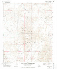
1982 Map of Ord Mountain
USGS Topo · Published 1987About this map
Ord Mountain Mountain dominates this arid landscape, a region defined by scattered mineral prospects and vital water sources in the high desert. Historically, the area served as a focal point for mining activity and cattle grazing, with remote outposts such as Hadden Well and Wills Well providing necessary water in an otherwise parched environment. The presence of the Maurmee Mine and several unnamed mines and prospects scattered across the slopes suggests a period of intense exploratory interest. Essential desert springs, including Aztec Spring, Sweetwater Spring, and Willow Spring, mark the terrain where geological faulting and topographic shifts allow moisture to reach the surface. To the south, the flat expanse of Tyler Valley and the Ericksen Dry Lake contrast with the surrounding peaks of the Newberry Mountains and Rodman Mountains, reflecting the characteristic basin-and-range geography of the San Bernardino desert.
Find a feature on this map
19 named features on this map. Tap any name to fly to it.
Don’t see what you’re looking for? This feature index may not catch every label — zoom into the map to look around manually.
Map Details
Editions of this 1982 Ord Mountain Map
3 editions found
Other maps of this area

1953 · San Bernardino
USGS Topo · 1:250,000

1955 · Newberry
USGS Topo · 1:62,500

1955 · Ord Mountains
USGS Topo · 1:62,500

1955 · Rodman Mountains
USGS Topo · 1:62,500

1956 · San Bernardino
USGS Topo · 1:250,000

1956 · Daggett
USGS Topo · 1:62,500

1957 · San Bernardino
USGS Topo · 1:250,000

1958 · San Bernardino
USGS Topo · 1:250,000

1959 · San Bernardino
USGS Topo · 1:250,000

1966 · San Bernardino
USGS Topo · 1:250,000