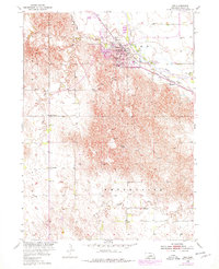
1954 Map of Ord
USGS Topo · Published 1978About this map
The town of Ord serves as the focal point of this Valley County landscape, situated along the banks of the North Loup River. This 1954 survey, updated with revisions in the 1970s, captures a transition from traditional river-and-rail infrastructure toward mid-century development. The river valley is a hub of activity, featuring Anderson Island and the Hardenbrook Dam, while the community infrastructure is marked by the central Courthouse and several educational institutions including High Sch and South Sch.
Find a feature on this map
29 named features on this map. Tap any name to fly to it.
Don’t see what you’re looking for? This feature index may not catch every label — zoom into the map to look around manually.
Map Details
Editions of this 1954 Ord Map
Other maps of this area

1899 · Loup
USGS Topo · 1:125,000

1951 · Arcadia East
USGS Topo · 1:24,000

1952 · Elyria
USGS Topo · 1:24,000

1952 · Comstock SE
USGS Topo · 1:24,000

1953 · Loup City NW
USGS Topo · 1:24,000

1953 · North Loup
USGS Topo · 1:24,000

1954 · Ord SE
USGS Topo · 1:24,000

1954 · Ord
USGS Topo · 1:24,000

1954 · Ord NE
USGS Topo · 1:24,000

1954 · Ord NW
USGS Topo · 1:24,000