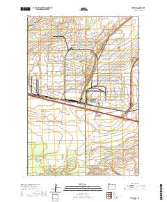
2020 Map of Ordnance
USGS Topo · Published 2020About this map
Agricultural infrastructure and water management define this portion of the Columbia Basin along the boundary of Morrow and Umatilla Counties. The landscape is heavily marked by irrigation engineering, notably the W Extension Irrigation Canal in the northwest and the Westland A Canal to the east, which support the geometric field patterns of the surrounding plateau. Local transit is facilitated by a network of rural routes such as Irrigon-Ordnance Rd and the aptly named Desert Rd, reflecting the arid environment that necessitated these water projects. Natural drainage features like Coyote Coulee and Fourmile Canyon interrupt the otherwise orderly grid of section lines and frontage roads. The map provides a clear look at the intersection of early 21st-century logistics and historic land divisions, evidenced by named thoroughfares like Stafford Hansel Rd and Homestead Ln.
Find a feature on this map
28 named features on this map. Tap any name to fly to it.
Don’t see what you’re looking for? This feature index may not catch every label — zoom into the map to look around manually.
Map Details
Editions of this 2020 Ordnance Map
This is the sole edition of this map. No revisions or reprints were ever made.
Other maps of this area

1906 · Blalock Island
USGS Topo · 1:125,000

1908 · Blalock Island
USGS Topo · 1:125,000

1908 · Umatilla
USGS Topo · 1:125,000

1953 · Pendleton
USGS Topo · 1:250,000

1956 · Pendleton
USGS Topo · 1:250,000

1962 · Ordnance
USGS Topo · 1:24,000

1962 · Paterson
USGS Topo · 1:24,000

1962 · Hermiston
USGS Topo · 1:24,000

1962 · Clarke
USGS Topo · 1:24,000
1962 · Irrigon
USGS Topo · 1:24,000