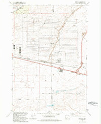
1993 Map of Ordnance
USGS Topo · Published 1993About this map
Umatilla Depot Activity dominates the central landscape of this Eastern Oregon survey, defined by its massive grid of storage structures and supporting infrastructure. This military installation, located near the Ordnance settlement, reflects the specialized logistical role the region played throughout the mid-to-late 20th century. The terrain is marked by the distinct Coyote Coulee and organized by an extensive network of water management, including the Irrigon Canal and the Lost Lake Canal which draw from the nearby Columbia River system to support agricultural development in an otherwise arid landscape.
Find a feature on this map
23 named features on this map. Tap any name to fly to it.
Don’t see what you’re looking for? This feature index may not catch every label — zoom into the map to look around manually.
Map Details
Editions of this 1993 Ordnance Map
This is the sole edition of this map. No revisions or reprints were ever made.
Other maps of this area

1906 · Blalock Island
USGS Topo · 1:125,000

1908 · Blalock Island
USGS Topo · 1:125,000

1908 · Umatilla
USGS Topo · 1:125,000

1953 · Pendleton
USGS Topo · 1:250,000

1956 · Pendleton
USGS Topo · 1:250,000

1962 · Ordnance
USGS Topo · 1:24,000

1962 · Paterson
USGS Topo · 1:24,000

1962 · Hermiston
USGS Topo · 1:24,000

1962 · Clarke
USGS Topo · 1:24,000
1962 · Irrigon
USGS Topo · 1:24,000