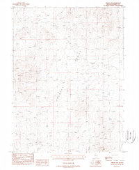
1987 Map of Oreana NW
USGS Topo · Published 1988About this map
The Trinity Range dominates this Pershing County landscape as it was documented in the mid-1980s. This high-altitude desert terrain is defined by a sparse but telling human imprint, primarily centered on mineral exploration and limited travel routes. Numerous Prospects are scattered across the slopes, indicating a history of small-scale mining activity and prospecting that characterizes this portion of the Great Basin. Access across the arid basins and steep ridges is maintained by Poker Brown Road and several 4wd tracks, which navigate between vital water sources like the isolated Spring and Well locations. These features illustrate the precarious nature of navigation and industry in a region where water and mineral potential dictate the placement of every trail and outpost.
Find a feature on this map
8 named features on this map. Tap any name to fly to it.
Don’t see what you’re looking for? This feature index may not catch every label — zoom into the map to look around manually.
Map Details
Editions of this 1987 Oreana NW Map
This is the sole edition of this map. No revisions or reprints were ever made.
Other maps of this area

1931 · Lovelock
USGS Topo · 1:250,000

1935 · Lovelock
USGS Topo · 1:250,000

1955 · Lovelock
USGS Topo · 1:250,000

1956 · Oreana
USGS Topo · 1:62,500

1959 · Lovelock
USGS Topo · 1:250,000

1971 · Rye Patch Reservoir South
USGS Topo · 1:24,000

1971 · Poker Brown
USGS Topo · 1:24,000

1981 · Natchez Spring
USGS Topo · 1:24,000
1981 · Poker Brown Gap
USGS Topo · 1:24,000

1981 · Poker Brown Spring
USGS Topo · 1:24,000