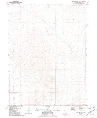
1981 Map of Poker Brown Gap
USGS Topo · Published 1982About this map
Poker Brown Gap serves as a primary passage between the high desert terrain of the Majuba Mountains and the broad expanse of Sage Valley. This 1981 edition, compiled from mid-1970s aerial photography, captures a landscape defined by seasonal water drainage and cattle-range infrastructure. Arid hydrology is prominent throughout the quadrangle, with Rabbithole Creek and Poker Brown Wash channeling occasional runoff through the dry basins. Evidence of human activity in this remote Nevada corridor is sparse but specific, marked by a Spring and a solitary Water Tank. A network of 4WD tracks provides the only access through the rocky outcrops and sagebrush, reflecting the region's enduring character as an isolated rangeland and mineral exploration area on the Pershing and Nevada county line.
Find a feature on this map
9 named features on this map. Tap any name to fly to it.
Don’t see what you’re looking for? This feature index may not catch every label — zoom into the map to look around manually.
Map Details
Editions of this 1981 Poker Brown Gap Map
This is the sole edition of this map. No revisions or reprints were ever made.
Other maps of this area

1931 · Lovelock
USGS Topo · 1:250,000

1935 · Lovelock
USGS Topo · 1:250,000

1955 · Lovelock
USGS Topo · 1:250,000

1956 · Oreana
USGS Topo · 1:62,500

1959 · Lovelock
USGS Topo · 1:250,000

1971 · Majuba Mtn
USGS Topo · 1:24,000

1971 · Poker Brown
USGS Topo · 1:24,000

1981 · Scossa
USGS Topo · 1:24,000

1981 · Placerites
USGS Topo · 1:24,000

1981 · Natchez Spring
USGS Topo · 1:24,000