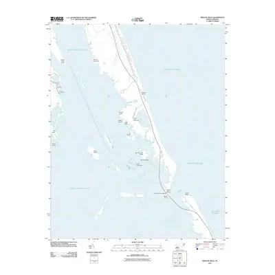
2011 Map of Oregon Inlet
USGS Topo · Published 2011About this map
Bodie Island Lighthouse stands as a sentinel over the shifting sands and intricate waterways where the Roanoke Sound, Atlantic Ocean, and Croatan Sound converge. This coastal landscape is defined by its dynamic island formations, including Herring Shoal Island, Big Tim Island, and Little Tim Island, which illustrate the volatile nature of the Outer Banks' geography. At the northern end of the inlet, the Herbert C Bonner Bridge provides the critical vehicular artery connecting the southern reaches to the mainland, while maritime activity is anchored at Mill Landing and Thicket Lump Marina. The map highlights a environment where narrow spits of land like North Point and South Point frame the tidal exchange, and recreational spots such as Coquina Beach represent the area's modern coastal use.
Find a feature on this map
26 named features on this map. Tap any name to fly to it.
Don’t see what you’re looking for? This feature index may not catch every label — zoom into the map to look around manually.
Map Details
Editions of this 2011 Oregon Inlet Map
This is the sole edition of this map. No revisions or reprints were ever made.
Other maps of this area

1943 · Roanoke Island
USGS Topo · 1:125,000

1953 · Wanchese
USGS Topo · 1:24,000

1953 · Roanoke Island NE
USGS Topo · 1:24,000

1953 · Stumpy Point
USGS Topo · 1:24,000

1953 · Manteo
USGS Topo · 1:24,000

1955 · Wanchese
USGS Topo · 1:250,000

1957 · Manteo
USGS Topo · 1:250,000

1960 · Manteo
USGS Topo · 1:250,000

1985 · Manteo
USGS Topo · 1:100,000
2002 · Stumpy Point
USGS Topo · 1:24,000