
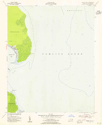
1953 Map of Stumpy Point
USGS Topo · Published 1956About this map
The coastal village of Stumpy Point serves as the focal point of this coastal survey, situated on the edge of the Croatan mainland along the western reaches of the Pamlico Sound. This mid-century map illustrates a landscape defined by the proximity of the sound, with the local economy and geography closely tied to the water, as evidenced by the Light and the noted Project Depth 7 Feet near the harbor. For genealogists and local historians, the inclusion of Shiloh Church and the nearby Shiloh Church Cem provides vital landmarks for family research in this fishing community.
Find a feature on this map
15 named features on this map. Tap any name to fly to it.
Don’t see what you’re looking for? This feature index may not catch every label — zoom into the map to look around manually.
Map Details
Editions of this 1953 Stumpy Point Map
2 editions found
Other maps of this area

1943 · Roanoke Island
USGS Topo · 1:125,000

1951 · Long Shoal Point
USGS Topo · 1:24,000

1953 · Wanchese
USGS Topo · 1:24,000

1953 · East Lake SE
USGS Topo · 1:24,000

1953 · Engelhard NE
USGS Topo · 1:24,000

1955 · Wanchese
USGS Topo · 1:250,000

1957 · Manteo
USGS Topo · 1:250,000

1960 · Manteo
USGS Topo · 1:250,000

1985 · Manteo
USGS Topo · 1:100,000
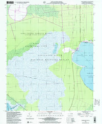
2000 · Engelhard NE
USGS Topo · 1:24,000