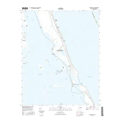
2016 Map of Oregon Inlet
USGS Topo · Published 2016About this map
Bodie Island and the northern tip of Pea Island are joined across the shifting waters of Oregon Inlet by the Herbert C Bonner Bridge. This coastal environment is defined by the protected lands of Cape Hatteras National Seashore and the Pinwr (Pea Island National Wildlife Refuge), preserving the delicate balance between the Atlantic Ocean and the sprawling sounds to the west. The map illustrates the specialized infrastructure required for this barrier island landscape, from the Bodie Island Lighthouse Rd to the various channels like Old House Channel and Roanoke Sound Channel that facilitate maritime traffic between Wanchese and the open sea. Inland waters are dotted with numerous small islands, including Duck Island, Herring Shoal Island, and Big Tim Island, highlighting the complex shoal systems and sloughs that have historically challenged and supported local mariners and watermen.
Find a feature on this map
47 named features on this map. Tap any name to fly to it.
Don’t see what you’re looking for? This feature index may not catch every label — zoom into the map to look around manually.
Map Details
Editions of this 2016 Oregon Inlet Map
This is the sole edition of this map. No revisions or reprints were ever made.
Other maps of this area
1943 · Roanoke Island
USGS Topo · 1:125,000
1953 · Wanchese
USGS Topo · 1:24,000
1953 · Roanoke Island NE
USGS Topo · 1:24,000
1953 · Stumpy Point
USGS Topo · 1:24,000
1953 · Manteo
USGS Topo · 1:24,000
1955 · Wanchese
USGS Topo · 1:250,000
1957 · Manteo
USGS Topo · 1:250,000
1960 · Manteo
USGS Topo · 1:250,000
1985 · Manteo
USGS Topo · 1:100,000
2002 · Stumpy Point
USGS Topo · 1:24,000