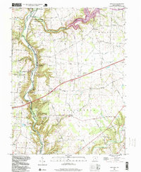
1996 Map of Oregonia
USGS Topo · Published 1999About this map
Fort Ancient State Memorial anchors the southern portion of this landscape, preserving significant earthworks including the Stone Circle and several Burial Mounds overlooking the Little Miami River. This 1990s survey shows a region defined by its sharp topography, where the river carves through the Caesar Creek Gorge and forms the eastern boundary of the Virginia Military District. The transition from river-bottom settlements like Oregonia and Mathers Mills to the upland plateaus of Harlans Flat is marked by steep wooded bluffs and numerous creek branches.
Find a feature on this map
85 named features on this map. Tap any name to fly to it.
Don’t see what you’re looking for? This feature index may not catch every label — zoom into the map to look around manually.
Map Details
Editions of this 1996 Oregonia Map
This is the sole edition of this map. No revisions or reprints were ever made.
Other maps of this area

1907 · Blanchester
USGS Topo · 1:62,500

1913 · Waynesville
USGS Topo · 1:62,500

1914 · Morrow
USGS Topo · 1:62,500

1915 · Waynesville
USGS Topo · 1:62,500

1916 · Morrow
USGS Topo · 1:62,500

1917 · Xenia
USGS Topo · 1:62,500

1947 · Columbus
USGS Topo · 1:250,000

1953 · Cincinnati
USGS Topo · 1:250,000

1955 · New Burlington
USGS Topo · 1:24,000
1955 · Lebanon
USGS Topo · 1:24,000