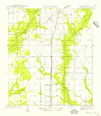
1956 Map of Oretta
USGS Topo · Published 1956About this map
Oretta, Seale, and Juanita emerge as central points of interest in this mid-century look at the Beauregard Parish landscape. The infrastructure of the era is dominated by the north-south corridor of the Kansas City Southern Railroad, which runs parallel to State Highway No 104. This transportation spine is intersected by remnants of an earlier economy, visible in several stretches of an Old Logging Railroad Grade, indicating the historical significance of the timber industry in this region.
Find a feature on this map
18 named features on this map. Tap any name to fly to it.
Don’t see what you’re looking for? This feature index may not catch every label — zoom into the map to look around manually.
Map Details
Editions of this 1956 Oretta Map
This is the sole edition of this map. No revisions or reprints were ever made.
Other maps of this area

1935 · Gordon
USGS Topo · 1:31,680

1947 · Singer
USGS Topo · 1:31,680

1947 · DeQuincy
USGS Topo · 1:31,680

1947 · Oretta
USGS Topo · 1:31,680

1947 · Kernan
USGS Topo · 1:31,680

1947 · Hyatt
USGS Topo · 1:31,680

1947 · Bivens
USGS Topo · 1:31,680

1947 · Beckwith School
USGS Topo · 1:31,680

1947 · Long Marsh
USGS Topo · 1:31,680

1949 · Kernan
USGS Topo · 1:31,680