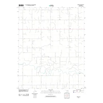
2010 Map of Orion
USGS Topo · Published 2010About this map
The North Canadian River meanders across the southern portion of this landscape, defining the rural character of Dewey County near the small settlement of Fonda. To the north, the community of Orion sits along a grid of local roads, centered by the Orion Cemetery and the northern flow of East Griever Creek. This 2010 survey illustrates a sparsely populated agricultural region, where the section lines of the Public Land Survey System are clearly reflected in the modern road network, including routes like Indian Rd. Local history and genealogy are anchored by specific landmarks such as Hope Cemetery, which provides a fixed point of reference for families whose roots are tied to these plains. The map details the transition from the river bottomlands to the upland prairie, showing a landscape shaped by both natural watercourses and the orderly expansion of rural Oklahoma infrastructure.
Find a feature on this map
23 named features on this map. Tap any name to fly to it.
Don’t see what you’re looking for? This feature index may not catch every label — zoom into the map to look around manually.
Map Details
Editions of this 2010 Orion Map
This is the sole edition of this map. No revisions or reprints were ever made.
Other maps of this area

1955 · Woodward
USGS Topo · 1:250,000

1958 · Woodward
USGS Topo · 1:250,000

1969 · Phroso
USGS Topo · 1:24,000

1969 · Cedardale
USGS Topo · 1:24,000

1969 · Glass Mountains SW
USGS Topo · 1:24,000

1972 · Canton NW
USGS Topo · 1:24,000

1972 · Hucmac
USGS Topo · 1:24,000

1972 · Canton SW
USGS Topo · 1:24,000

1972 · Seiling
USGS Topo · 1:24,000
1972 · Taloga
USGS Topo · 1:24,000