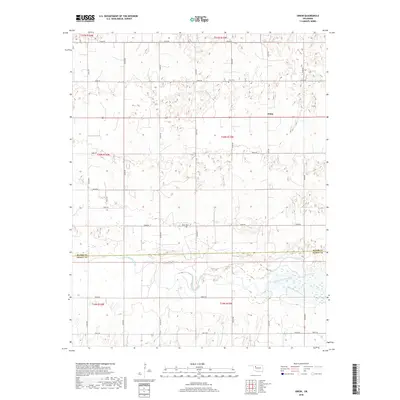
2018 Map of Orion
USGS Topo · Published 2018About this map
The North Canadian River meanders across the southern portion of this landscape, forming a natural divide between Major Co and Dewey Co. The settlement of Orion sits just north of the county line, centered near the intersection of several section-line roads. This area of Oklahoma reflects a rural agricultural grid pattern established by the Public Land Survey System, as evidenced by the numerous township and range designations such as t20n r15w. Local genealogy and family history are tied to small community centers like Orion Cem and Hope Cem, which remain as fixed landmarks amidst the open land. Modern infrastructure is represented by a well-defined network of local roads including Indian Rd and e0610 RD, which follow the traditional square-mile section boundaries.
Find a feature on this map
29 named features on this map. Tap any name to fly to it.
Don’t see what you’re looking for? This feature index may not catch every label — zoom into the map to look around manually.
Map Details
Editions of this 2018 Orion Map
This is the sole edition of this map. No revisions or reprints were ever made.
Other maps of this area

1955 · Woodward
USGS Topo · 1:250,000

1958 · Woodward
USGS Topo · 1:250,000

1969 · Phroso
USGS Topo · 1:24,000

1969 · Cedardale
USGS Topo · 1:24,000

1969 · Glass Mountains SW
USGS Topo · 1:24,000

1972 · Canton NW
USGS Topo · 1:24,000

1972 · Hucmac
USGS Topo · 1:24,000

1972 · Canton SW
USGS Topo · 1:24,000

1972 · Seiling
USGS Topo · 1:24,000
1972 · Taloga
USGS Topo · 1:24,000