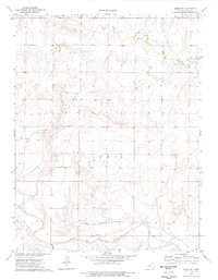
1974 Map of Orion SW
USGS Topo · Published 1977About this map
The Butterfield Trail cuts through the southern half of this Gove County landscape, marking the historic path of the Butterfield Overland Despatch. The terrain is defined by the drainage systems of the Smoky Hill River and its northern tributaries, including Plum Creek and Hell Cr. This 1974 survey shows a largely undeveloped prairie environment where human activity is limited to a few resource-driven sites like a Quarry and a Sandpit. Evidence of early pioneer passage or isolated homesteading is found in the simple Grave noted in the western section of the map. The topography rises toward the Lewis township area, providing a clear view of the drainage patterns and the approximate historical route that once connected the central plains to the western frontier.
Find a feature on this map
11 named features on this map. Tap any name to fly to it.
Don’t see what you’re looking for? This feature index may not catch every label — zoom into the map to look around manually.
Map Details
Editions of this 1974 Orion SW Map
This is the sole edition of this map. No revisions or reprints were ever made.
Other maps of this area

1939 · Sandon
USGS Topo · 1:62,500

1942 · Sandon
USGS Topo · 1:62,500

1955 · Scott City
USGS Topo · 1:250,000

1958 · Scott City
USGS Topo · 1:250,000

1972 · Orion NE
USGS Topo · 1:24,000

1972 · Orion
USGS Topo · 1:24,000

1972 · Elkader NE
USGS Topo · 1:24,000

1974 · Cheyenne Creek
USGS Topo · 1:24,000
1974 · Orion SE
USGS Topo · 1:24,000

1974 · Healy NW
USGS Topo · 1:24,000