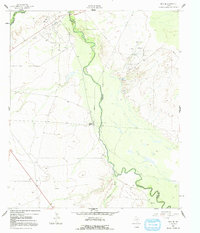
1961 Map of Orla SE
USGS Topo · Published 1991About this map
The Pecos River carves a winding path through the arid Trans-Pecos landscape, serving as the border between Reeves and Loving Counties. During the early 1960s, this desert region was defined by industrial energy development, anchored by the East Tunstill Oil Field and a complex network of pipelines that traverse the plains. Infrastructure to support this extraction is evident at Mason Station, where a Substation and Gaging Sta are located along the riverbank.
Find a feature on this map
14 named features on this map. Tap any name to fly to it.
Don’t see what you’re looking for? This feature index may not catch every label — zoom into the map to look around manually.
Map Details
Editions of this 1961 Orla SE Map
2 editions found
Other maps of this area

1925 · Orla 2-b
USGS Topo · 1:48,000

1931 · Orla
USGS Topo · 1:62,500

1954 · Pecos
USGS Topo · 1:250,000

1957 · Pecos
USGS Topo · 1:250,000

1961 · Anderson Ranch
USGS Topo · 1:24,000

1961 · Orla SE
USGS Topo · 1:24,000

1961 · Lindley Ranch
USGS Topo · 1:24,000

1961 · Narrow Bow Draw
USGS Topo · 1:24,000

1968 · Threemile Draw
USGS Topo · 1:24,000

1968 · Orla
USGS Topo · 1:24,000