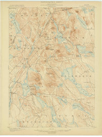
1900 Map of Orland
USGS Topo · Published 1902About this map
Alamoosook Lake and the winding Orland River anchor the western portion of this turn-of-the-century coastal Maine survey. The landscape is defined by a dense concentration of interior ponds and granite peaks, where early commerce followed the Maine Central R.R. through the hills near Phillips Lake. A distinct federal presence is marked by the U.S. Fish Hatchery located near Craig Pond, highlighting the importance of the region's inland fisheries at the end of the nineteenth century. Small milling and farming communities such as Bucks Mills, Santiago, and Nicolin are scattered throughout the hills, connected by primitive road networks that navigate around significant bogs and marshes like Mann Bog and Coon Bog. The map illustrates a rural economy transitioning as the railroad provided new access to seasonal destinations like the Lake House, contrasting with the established village centers of Orland and East Holden.
Find a feature on this map
94 named features on this map. Tap any name to fly to it.
Don’t see what you’re looking for? This feature index may not catch every label — zoom into the map to look around manually.
Map Details
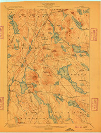
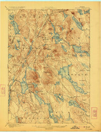
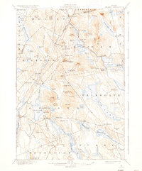
Editions of this 1900 Orland Map
6 editions found

Other maps of this area

1900 · Orland
USGS Topo · 1:62,500

1900 · Bucksport
USGS Topo · 1:62,500

1902 · Orono
USGS Topo · 1:62,500

1902 · Bucksport
USGS Topo · 1:62,500

1902 · Bangor
USGS Topo · 1:62,500

1902 · Castine
USGS Topo · 1:62,500

1904 · Castine
USGS Topo · 1:62,500

1904 · Mount Desert
USGS Topo · 1:62,500

1904 · Bluehill
USGS Topo · 1:62,500

1905 · Penobscot Bay
USGS Topo · 1:125,000