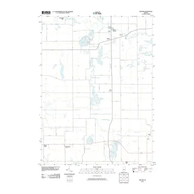
2010 Map of Orland
USGS Topo · Published 2010About this map
Orland serves as the central hub of this northern Indiana landscape, where the Fawn River and Pigeon Creek drainage systems define the local geography. The map reveals a high density of glacial lakes, including Wall Lake, Appleman Lake, and Deep Lake, which are interconnected by a complex network of county roads. Industrial and conservation efforts are evidenced by the Fawn River Fish Hatchery and the settlement of Greenfield Mills to the northwest. For those researching family history, the sheet is exceptionally well-documented with local burial grounds such as Carlton Cemetery, Greenlawn Cemetery, Jackson Prairie Cemetery, and the East Springfield United Methodist Cemetery. The small settlements of Flint and Brushy Prairie anchor the southern portion of the quadrangle, illustrating the enduring rural community structure of Steuben County in the early 21st century.
Find a feature on this map
76 named features on this map. Tap any name to fly to it.
Don’t see what you’re looking for? This feature index may not catch every label — zoom into the map to look around manually.
Map Details
Editions of this 2010 Orland Map
This is the sole edition of this map. No revisions or reprints were ever made.
Other maps of this area

1940 · Orland
USGS Topo · 1:24,000

1941 · Orland
USGS Topo · 1:24,000

1941 · Angola West
USGS Topo · 1:24,000

1942 · Ashley
USGS Topo · 1:24,000

1942 · Angola West
USGS Topo · 1:24,000

1942 · Stroh
USGS Topo · 1:24,000

1947 · Mongo
USGS Topo · 1:24,000

1947 · Wolcottville
USGS Topo · 1:24,000

1953 · Fort Wayne
USGS Topo · 1:250,000

1956 · Fort Wayne
USGS Topo · 1:250,000