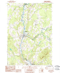
1986 Map of Orleans
USGS Topo · Published 1986About this map
The Barton River and its tributary, the Willoughby River, converge near the village of Orleans in this mid-1980s look at northern Vermont. The landscape is characterized by a mix of agricultural valley floors and prominent high points such as Barton Mtn and Prospect Hill. Several distinct clusters of settlement are visible across the township lines of Brownington and Barton, including Brownington Village and Brownington Center. The presence of the Willoughby Falls State Wildlife Management Area and the South Bay State Wildlife Management Area suggests a region dedicated to conservation and the preservation of its wetland habitats. Further south, the town of Barton marks a significant population center near May Pond Brook, while smaller hamlets like Evansville punctuate the eastern reaches of the quadrangle along the state roads.
Find a feature on this map
35 named features on this map. Tap any name to fly to it.
Don’t see what you’re looking for? This feature index may not catch every label — zoom into the map to look around manually.
Map Details
Editions of this 1986 Orleans Map
This is the sole edition of this map. No revisions or reprints were ever made.
Other maps of this area

1919 · Lake Memphremagog
USGS Topo · 1:62,500

1920 · Derby
USGS Topo · 1:62,500

1920 · Irasburg
USGS Topo · 1:62,500

1923 · Irasburg
USGS Topo · 1:48,000

1923 · Lake Memphremagog
USGS Topo · 1:48,000

1925 · Irasburg
USGS Topo · 1:62,500

1925 · Memphremagog
USGS Topo · 1:62,500

1928 · Hardwick
USGS Topo · 1:62,500

1934 · Hardwick
USGS Topo · 1:48,000

1935 · Lyndonville
USGS Topo · 1:48,000