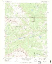
1977 Map of Orno Peak
USGS Topo · Published 1978About this map
Routt National Forest and the White River National Forest converge at this high-altitude plateau in the late 1970s. The landscape is defined by the massive plateau of The Flat Tops, where numerous high-country reservoirs and alpine lakes feed the headwaters of the Bear River and Coal Creek. Water management is central to the area's geography, evidenced by the Upper Stillwater Reservoir (Yampa Reservoir) and the Gaging Sta downstream.
Find a feature on this map
49 named features on this map. Tap any name to fly to it.
Don’t see what you’re looking for? This feature index may not catch every label — zoom into the map to look around manually.
Map Details
Editions of this 1977 Orno Peak Map
3 editions found
Other maps of this area

1927 · Glenwood Springs
USGS Topo · 1:125,000

1930 · Glenwood Springs
USGS Topo · 1:125,000

1954 · Craig
USGS Topo · 1:250,000

1957 · Craig
USGS Topo · 1:250,000

1957 · Leadville
USGS Topo · 1:250,000

1958 · Craig
USGS Topo · 1:250,000

1959 · Leadville
USGS Topo · 1:250,000

1960 · Leadville
USGS Topo · 1:250,000

1960 · Craig
USGS Topo · 1:250,000

1962 · Leadville
USGS Topo · 1:250,000