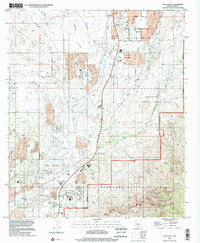
1996 Map of Oro Valley
USGS Topo · Published 2002About this map
Oro Valley and the northern reaches of the Tucson basin are defined by a complex drainage system flowing toward the Cañada del Oro. In the mid-1990s, the area reflects a transition from ranching heritage to suburban expansion, evidenced by the presence of Steam Pump Ranch alongside burgeoning residential streets and a Golf Course. To the east, the rising terrain of the Coronado National Forest and Pusch Ridge Wilderness creates a sharp natural boundary for the valley's development. Local education and recreation centers are well-established, including Canyon del Oro High Sch and the extensive grounds of Catalina State Park. Numerous ephemeral washes, such as Honey Bee Canyon and Big Wash, carve through the landscape, illustrating the desert's hydrological patterns and providing significant landmarks for local history and topography.
Find a feature on this map
51 named features on this map. Tap any name to fly to it.
Don’t see what you’re looking for? This feature index may not catch every label — zoom into the map to look around manually.
Map Details
Editions of this 1996 Oro Valley Map
This is the sole edition of this map. No revisions or reprints were ever made.
Other maps of this area

1904 · Tucson
USGS Topo · 1:125,000

1905 · Tucson
USGS Topo · 1:125,000

1911 · Winkelman
USGS Topo · 1:125,000

1913 · Winkelman
USGS Topo · 1:125,000

1934 · Tucson Mountains
USGS Topo · 1:125,000

1934 · Newman Peak
USGS Topo · 1:125,000

1947 · Cortaro
USGS Topo · 1:62,500

1956 · Tucson
USGS Topo · 1:250,000

1957 · Sabino Canyon
USGS Topo · 1:24,000

1957 · Cortaro
USGS Topo · 1:62,500