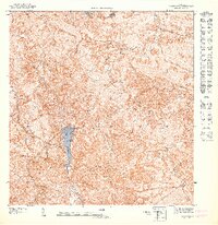
1947 Map of Orocovis NO
USGS Topo · Published 1947About this map
Lago de Matrullas serves as a central landmark in this 1940s survey of the Cordillera Central region, where the mountainous terrain of the interior highlands dictates the path of every stream and boundary. This preliminary map, prepared by the U.S. Geological Survey and authorized by Orlando R. Méndez, illustrates the complex hydrology of the Río Matrullas and Río Bauta drainage basins. The boundary between Municipio de Morovis and Municipio de Orocovis traverses some of the highest points in the area, including the prominent peaks of Cerro Mime and Cerro Taita. In this era, the landscape is defined by its verticality, with Peña La Francia standing over a network of winding trails and remote buildings that reflect the rural settlement patterns of the Puerto Rican heartland before modern infrastructure expanded through the mountains.
Find a feature on this map
8 named features on this map. Tap any name to fly to it.
Don’t see what you’re looking for? This feature index may not catch every label — zoom into the map to look around manually.
Map Details
Editions of this 1947 Orocovis NO Map
This is the sole edition of this map. No revisions or reprints were ever made.
Other maps of this area

1946 · Ciales
USGS Topo · 1:30,000

1946 · Jayuya
USGS Topo · 1:30,000

1946 · Florida
USGS Topo · 1:30,000

1946 · Orocovis
USGS Topo · 1:30,000
1947 · Orocovis NE
USGS Topo · 1:10,000
1947 · Ciales SO
USGS Topo · 1:10,000
1947 · Orocovis SO
USGS Topo · 1:10,000
1947 · Orocovis SE
USGS Topo · 1:10,000
1947 · Jayuya NE
USGS Topo · 1:10,000
1947 · Jayuya SE
USGS Topo · 1:10,000