
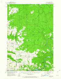
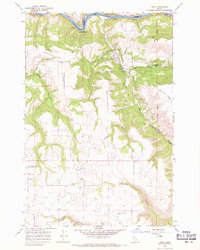
1984 Map of Orofino West
USGS Topo · Published 1985About this map
The Clearwater River serves as the focal point for development in this Idaho panhandle region, where the communities of Orofino and Riverside sit along its banks. The map reveals a landscape defined by sharp transitions from the river valley up to the high plateaus of Central Ridge, an area encompassing portions of the Nez Perce Indian Reservation. Civic life and infrastructure are well-documented, with the State Hospital North, Orofino High Sch, and a Ranger Station all located within the primary river settlement.
Find a feature on this map
27 named features on this map. Tap any name to fly to it.
Don’t see what you’re looking for? This feature index may not catch every label — zoom into the map to look around manually.
Map Details
Editions of this 1984 Orofino West Map
This is the sole edition of this map. No revisions or reprints were ever made.
Other maps of this area

1924 · Kamiah
USGS Topo · 1:125,000

1955 · Pullman
USGS Topo · 1:250,000

1958 · Pullman
USGS Topo · 1:250,000
1961 · Ahsahka
USGS Topo · 1:62,500
1967 · Mohler
USGS Topo · 1:24,000
1967 · Fletcher
USGS Topo · 1:24,000
1967 · Sixmile Creek
USGS Topo · 1:24,000
1967 · Peck
USGS Topo · 1:24,000

1967 · Orofino West
USGS Topo · 1:24,000
1967 · Orofino East
USGS Topo · 1:24,000