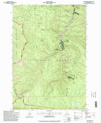
1995 Map of Orogrande
USGS Topo · Published 1999About this map
Orogrande and the neighboring site of Old Orogrande serve as the focal points for this mid-1990s look into the mining history of the Nez Perce National Forest. The landscape is heavily marked by the region's extractive past, with extensive Dredge Tailings visible along the Crooked River and a high density of named mining operations including the Orogrande Frisco Mine, Umatilla Mine, and the Penman Mine. The remote nature of these operations is underscored by the presence of the Orogrande Airstrip, which provided critical access to this high-elevation terrain.
Find a feature on this map
42 named features on this map. Tap any name to fly to it.
Don’t see what you’re looking for? This feature index may not catch every label — zoom into the map to look around manually.
Map Details
Editions of this 1995 Orogrande Map
This is the sole edition of this map. No revisions or reprints were ever made.
Other maps of this area

1931 · Buffalo Hump
USGS Topo · 1:125,000

1934 · Buffalo Hump
USGS Topo · 1:125,000

1956 · Elk City
USGS Topo · 1:250,000

1960 · Elk City
USGS Topo · 1:250,000

1962 · Golden
USGS Topo · 1:24,000

1962 · Center Star Mtn
USGS Topo · 1:24,000

1966 · Elk City
USGS Topo · 1:24,000

1977 · Silver Spur Ridge
USGS Topo · 1:24,000

1978 · Moose Butte
USGS Topo · 1:24,000

1979 · Buffalo Hump
USGS Topo · 1:24,000