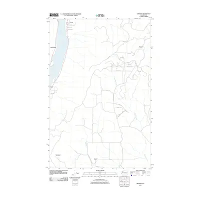
2011 Map of Orondo
USGS Topo · Published 2011About this map
Orondo and Wagnersburg sit along the eastern banks of the Columbia River in a landscape defined by dramatic elevation changes and a dense network of high-desert roads. This 2011 survey illustrates the rural development of Chelan County, where local thoroughfares like Badger Mountain Rd Sw and Longview Rd Sw wind through the hills toward the Badger Mountain Lookout Tower. The terrain is deeply incised by McGinnis Canyon to the northeast, while the southern reaches of the map are drained by Beaver Creek and Rock Island Creek. A sense of local community and history is anchored by the South Side Cemetery, positioned near the junction of several county roads in the southern flats. The map provides a detailed view of the modern road network, from named lanes like Rancho Penranda to the service roads supporting the fruit-growing region near the river.
Find a feature on this map
36 named features on this map. Tap any name to fly to it.
Don’t see what you’re looking for? This feature index may not catch every label — zoom into the map to look around manually.
Map Details
Editions of this 2011 Orondo Map
This is the sole edition of this map. No revisions or reprints were ever made.
Other maps of this area

1901 · Chelan
USGS Topo · 1:125,000

1912 · Malaga
USGS Topo · 1:48,000

1913 · Wenatchee
USGS Topo · 1:62,500

1914 · Malaga
USGS Topo · 1:62,500

1915 · Wenatchee
USGS Topo · 1:62,500

1920 · Colockum Pass
USGS Topo · 1:125,000

1922 · Colockum Pass
USGS Topo · 1:125,000

1957 · Wenatchee
USGS Topo · 1:250,000
1966 · Malaga NE
USGS Topo · 1:24,000

1966 · Rock Island
USGS Topo · 1:24,000