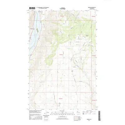
2017 Map of Orondo
USGS Topo · Published 2017About this map
The Columbia River defines the western edge of this landscape, separating Chelan and Douglas counties near the settlements of Orondo and Wagnersburg. This 2017 survey captures the high-desert terrain of the interior, where the plateau rises toward Badger Mtn and is dissected by drainage systems like Rock Island Cr and McGinnis Canyon. The presence of the South Side Cemetery south of Beaver Cr provides a focal point for local genealogy, while the development of modern rural access is traced through a dense network of named roads like Orondo Loop Rd and Sunset Way. The riverfront at Lake Entiat shows the modern shoreline and transportation corridor along the water's edge, contrasting with the high, dry draws of the eastern uplands.
Find a feature on this map
56 named features on this map. Tap any name to fly to it.
Don’t see what you’re looking for? This feature index may not catch every label — zoom into the map to look around manually.
Map Details
Editions of this 2017 Orondo Map
This is the sole edition of this map. No revisions or reprints were ever made.
Other maps of this area

1901 · Chelan
USGS Topo · 1:125,000

1912 · Malaga
USGS Topo · 1:48,000

1913 · Wenatchee
USGS Topo · 1:62,500

1914 · Malaga
USGS Topo · 1:62,500

1915 · Wenatchee
USGS Topo · 1:62,500

1920 · Colockum Pass
USGS Topo · 1:125,000

1922 · Colockum Pass
USGS Topo · 1:125,000

1957 · Wenatchee
USGS Topo · 1:250,000
1966 · Malaga NE
USGS Topo · 1:24,000

1966 · Rock Island
USGS Topo · 1:24,000